Hail Magic › Hail maps › Montana
◆ MONTANA HAIL HISTORY
Montana hail map & storm history
Montana has recorded 659 hail days in the past 5 years, with hail up to 5.00″ (Softball). Most recent: Nov 14, 2026. Browse 141 cities with hail reports.
✓ Data compiled by a degreed meteorologist from NOAA & NWS sources
659Hail days in the past 5 years
3.50″Largest ground report · Winnett, Jun 16, 2025
5.00″Largest radar-estimated hail
141Cities with hail reports
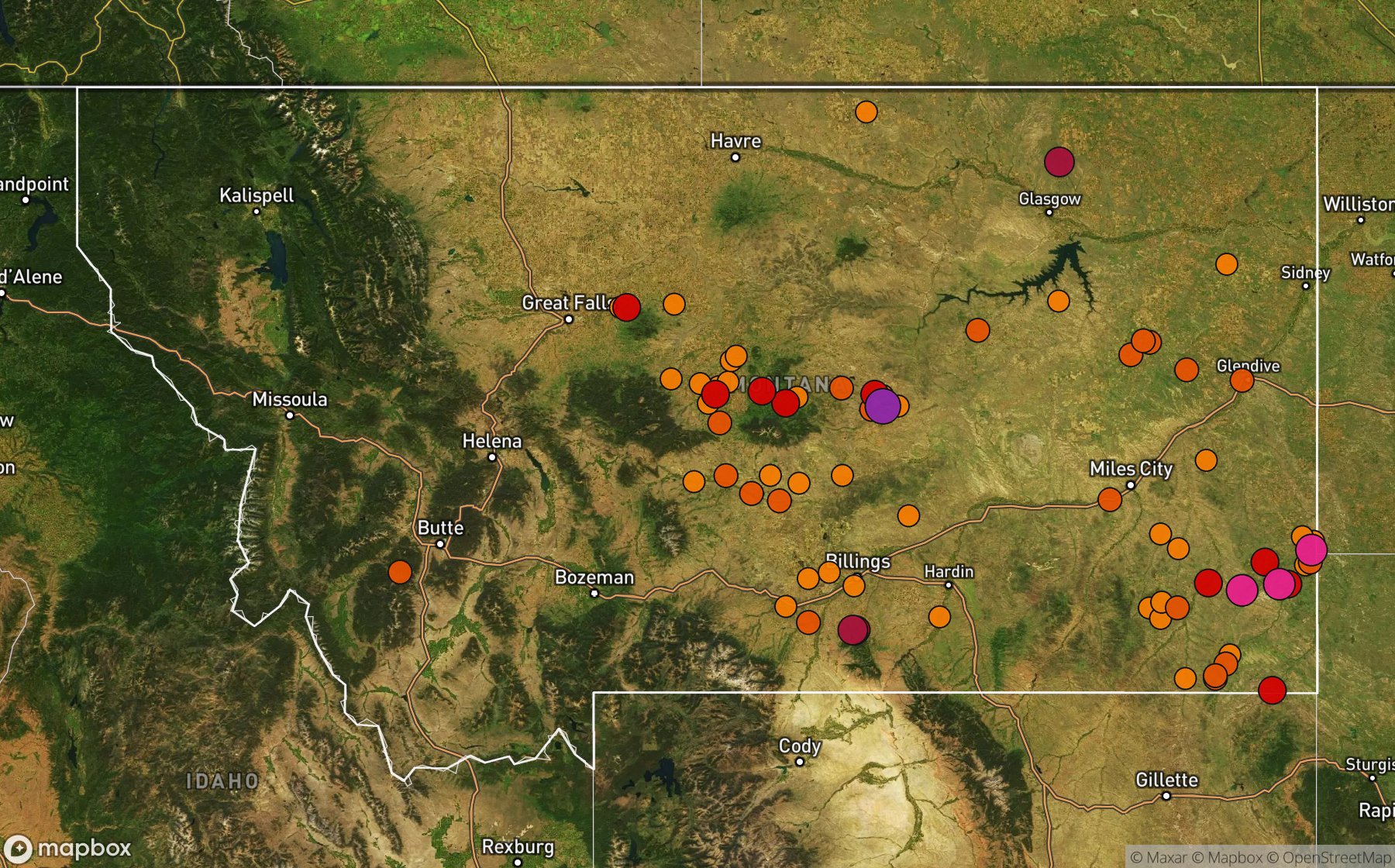
Largest NWS / NCEI hail reports across Montana. Dot size and color show hail size.
Recent hail days in Montana
| Date | Peak hail | Radar estimate | NWS reports |
|---|---|---|---|
| Nov 14, 2026 | 1.00″ | 1.00″ | — |
| Nov 13, 2026 | 1.00″ | 1.00″ | — |
| Nov 12, 2026 | 1.50″ | 1.50″ | — |
| Nov 11, 2026 | 1.50″ | 1.50″ | — |
| Nov 6, 2026 | 2.00″ | 2.00″ | — |
| Nov 3, 2026 | 1.75″ | 1.75″ | — |
| Oct 28, 2026 | 0.75″ | 0.75″ | — |
| Oct 27, 2026 | 2.75″ | 2.75″ | — |
| Oct 23, 2026 | 1.00″ | 1.00″ | — |
| Oct 17, 2026 | 1.50″ | 1.50″ | — |
| Oct 14, 2026 | 0.75″ | 0.75″ | — |
| Oct 11, 2026 | 0.75″ | 0.75″ | — |
| Oct 8, 2026 | 1.00″ | 1.00″ | — |
| Oct 3, 2026 | 1.50″ | 1.50″ | — |
| Oct 1, 2026 | 1.00″ | 1.00″ | — |
| Sep 28, 2026 | 1.25″ | 1.25″ | — |
| Sep 23, 2026 | 0.75″ | 0.75″ | — |
| Sep 19, 2026 | 0.75″ | 0.75″ | — |
| Sep 18, 2026 | 1.00″ | 1.00″ | — |
| Sep 14, 2026 | 1.25″ | 1.25″ | — |
| Sep 12, 2026 | 1.00″ | 1.00″ | — |
| Sep 11, 2026 | 0.75″ | 0.75″ | — |
| Sep 7, 2026 | 4.00″ | 4.00″ | — |
| Sep 6, 2026 | 1.75″ | 1.75″ | — |
| Sep 3, 2026 | 2.25″ | 2.25″ | — |
Most hail-hit cities
Billings Logan Arpt (10), Laurel Muni Arpt (9), Olive (9), Great Falls (7), Winnett (7), Glendive (6), Ekalaka (5), Grassrange (5), Webster (5), Brockway (4), Circle (4), Columbus (4)
Hail history for every Montana city (141)
(Hln)Helena Rgnl Arp(Lwt)Lewiston Muni AActonAlzadaAshuelotBakerBaylorBecketBelltowerBenchlandBiddleBig SagBig TimberBillingsBillings HgtsBillings Logan ArptBlatchfordBridgerBroadusBroadviewBrockwayBrownBrowningBrusettBuffaloButteCamasCampsiteCarltonCircleClancyClinton Eliott ArptColumbusCrow AgencyCulbertsonDagmarDanversDentonEast HelenaEastham JctEkalakaElsoEnidEpsieEvergreenFairfieldFlatwillowFlaxvilleForestgroveFranklinFroidFt Benton ArptGarneillGeraldine ArptGlasgowGlendiveGlentanaGrass VlyGrassrangeGrassrange Clark ArpGreat FallsHalf MoonHammondHardinHardin AirparkHarlowtonHavreHaxby PointHedgesvilleHighwoodHobsonHuntleyIronIsmayJolietJudith GapKalispell City ArptKammKirbyKleinLambertLame DeerLarslanLaurelLaurel Muni ArptLindsay Divide DotLockwoodLupferMaiden RockMalta South DotMansonMariasMartin CityMc CloudMelvilleMiles CityMill IronMoccasinMoltNoxonOliveOlliePiperPlacerPlevnaPompeys PillarPortagePowdervillePryorRed LodgeRedstoneRidgeRobertsRockvaleRoss ForkRoundupRoundup ArptRyegateSaint MarieSayleScobeyShawmutSheffieldShepherdSioux Pass DotSt XavierStanfordSunburst ArptSutherlandTerryTurnerTuscorTwodotUticaVolborgWebsterWibauxWilsallWinifred ArptWinnettWise River
Data window: NOAA MRMS radar hail swaths Oct 2021 – Nov 2026; NWS / NCEI Storm Events reports Nov 2024 – Jul 2026; CoCoRaHS volunteer reports Oct 2021 – present. Radar hail sizes are NOAA MRMS Maximum Estimated Size of Hail (MESH) and are estimates, not ground truth.