Hail Magic › Hail maps › Pennsylvania
◆ PENNSYLVANIA HAIL HISTORY
Pennsylvania hail map & storm history
Pennsylvania has recorded 605 hail days in the past 5 years, with hail up to 6.00″ (Softball). Most recent: Nov 12, 2026. Browse 145 cities with hail reports.
✓ Data compiled by a degreed meteorologist from NOAA & NWS sources
605Hail days in the past 5 years
2.50″Largest ground report · Chevy Chase Hgts, May 4, 2025
6.00″Largest radar-estimated hail
145Cities with hail reports
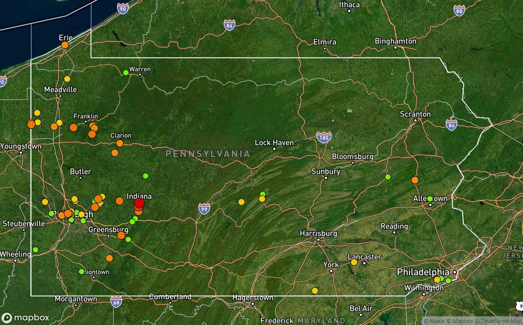
Largest NWS / NCEI hail reports across Pennsylvania. Dot size and color show hail size.
Recent hail days in Pennsylvania
| Date | Peak hail | Radar estimate | NWS reports |
|---|---|---|---|
| Nov 12, 2026 | 1.50″ | 1.50″ | — |
| Nov 11, 2026 | 1.00″ | 1.00″ | — |
| Nov 3, 2026 | 0.75″ | 0.75″ | — |
| Oct 30, 2026 | 1.25″ | 1.25″ | — |
| Oct 29, 2026 | 1.00″ | 1.00″ | — |
| Oct 24, 2026 | 2.50″ | 2.50″ | — |
| Oct 23, 2026 | 1.25″ | 1.25″ | — |
| Oct 18, 2026 | 1.50″ | 1.50″ | — |
| Oct 16, 2026 | 0.75″ | 0.75″ | — |
| Oct 11, 2026 | 0.75″ | 0.75″ | — |
| Oct 7, 2026 | 1.50″ | 1.50″ | — |
| Oct 5, 2026 | 1.00″ | 1.00″ | — |
| Sep 25, 2026 | 0.75″ | 0.75″ | — |
| Sep 24, 2026 | 0.75″ | 0.75″ | — |
| Sep 22, 2026 | 1.25″ | 1.25″ | — |
| Sep 18, 2026 | 0.75″ | 0.75″ | — |
| Sep 17, 2026 | 0.75″ | 0.75″ | — |
| Sep 13, 2026 | 0.75″ | 0.75″ | — |
| Sep 12, 2026 | 1.25″ | 1.25″ | — |
| Sep 10, 2026 | 0.75″ | 0.75″ | — |
| Sep 4, 2026 | 1.25″ | 1.25″ | — |
| Sep 3, 2026 | 2.00″ | 2.00″ | — |
| Sep 2, 2026 | 2.25″ | 2.25″ | — |
| Sep 1, 2026 | 1.75″ | 1.75″ | — |
| Aug 31, 2026 | 1.75″ | 1.75″ | — |
Most hail-hit cities
Highcliff (6), Chevy Chase Hgts (4), Claypoole Hgts (3), Rutledge (3), Shalecrest (3), State College (3), Bakerstown Station (2), Ben Avon (2), Black Lick (2), Emsworth (2), Gastonville (2), Glenfield (2)
Hail history for every Pennsylvania city (145)
(Fkl)Lamberton Fld F(Pit)Gtr Pittsburgh(Unv)Univ Park StateAltoona Peterson ArpAmbridgeArnolaBakerstown StationBandanaBeaver FallsBellevueBelltonBelmontBen AvonBlack LickBrockportBudavilleBuhlsButlerCambridge SpgsCardaleCarnotCenterportCharleroiChevy Chase HgtsClarionClarion Parker ArptClarks MillsClaypoole HgtsCovodeCranberryCultsvilleDravosburgDunlevyEast BradfordEdgecliffEmsworthErieFairmount CityFairviewFairview KnollsFayette CityFinleyvilleForest GroveForest HillsFox ChapelFranklinFredericksburgFt MiffinGastonvilleGettysburg JctGirtyGlenfieldGodfreyGrace ParkHaddockHadleyHarrityHarshavilleHenleinHighcliffHighlandHighvilleHoltHomer CityHutchinsonJamestownKenwoodKiskiminetas JctKnox DaleKulptownLansfordLaurel GardensLeetsdaleLindenLongbridgeLower BurrellLoyalhannaLudwigs CornerLumber CityMaple ShadeMariannaMarsMarshall HgtsMaysvilleMiddleboroMillerstownMilroyMonacaMoonMooreheadvilleMt AetnaMt PleasantNatronaNatrona HgtsNeville IsNew BethlehemNew BloomfieldNew CastleNew KensingtonNew LexingtonNew VernonOgleOptionOrangevilleParkviewPhilipsburgPottstownPrimosRaymiltonRed LionRiverviewRocklandRockledgeRutledgeSandy LakeSaulsburgShalecrestShearersburgShoenersvilleSilver SpgSouth HgtsStahlstownStandard ShaftState CollegeSteel CityStoops FerryStoweStrangfordTrade CityUnity JctVanVenusWalkertownWayneWeinel XrdsWellsboroWertzvilleWest BrownsvilleWest NewtonWest OvertonWest ViewWilkins TownshipWilliamsburgWoodycrestYoungsville
Data window: NOAA MRMS radar hail swaths Oct 2021 – Nov 2026; NWS / NCEI Storm Events reports Nov 2024 – Jul 2026; CoCoRaHS volunteer reports Oct 2021 – present. Radar hail sizes are NOAA MRMS Maximum Estimated Size of Hail (MESH) and are estimates, not ground truth.