Hail Magic › Hail maps › Wyoming
◆ WYOMING HAIL HISTORY
Wyoming hail map & storm history
Wyoming has recorded 461 hail days in the past 5 years, with hail up to 6.00″ (Softball). Most recent: Oct 27, 2026. Browse 93 cities with hail reports.
✓ Data compiled by a degreed meteorologist from NOAA & NWS sources
461Hail days in the past 5 years
3.00″Largest ground report · Arcola, Aug 2, 2025
6.00″Largest radar-estimated hail
93Cities with hail reports
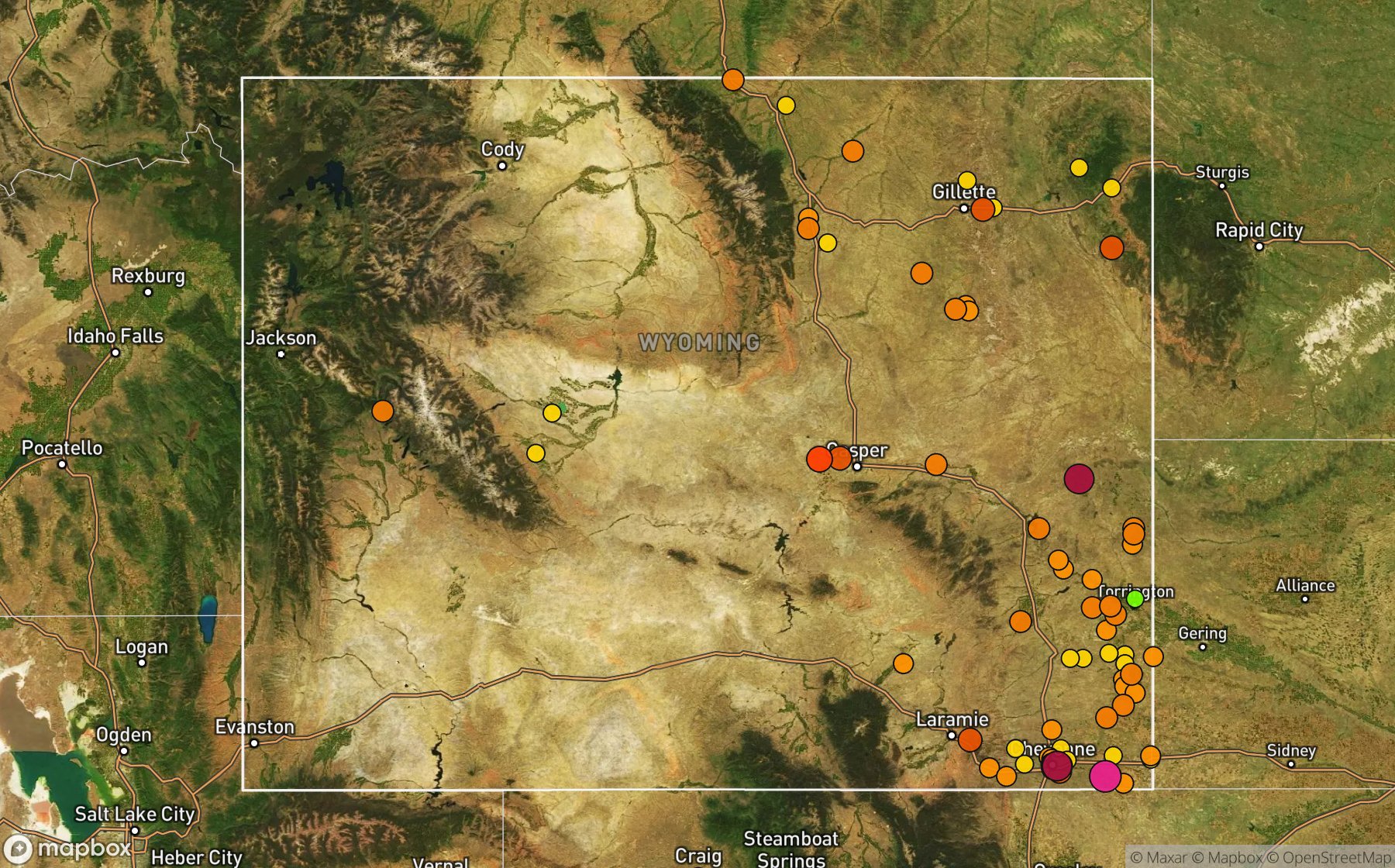
Largest NWS / NCEI hail reports across Wyoming. Dot size and color show hail size.
Recent hail days in Wyoming
| Date | Peak hail | Radar estimate | NWS reports |
|---|---|---|---|
| Oct 27, 2026 | 0.75″ | 0.75″ | — |
| Sep 28, 2026 | 1.25″ | 1.25″ | — |
| Sep 23, 2026 | 1.00″ | 1.00″ | — |
| Sep 22, 2026 | 0.75″ | 0.75″ | — |
| Sep 20, 2026 | 1.50″ | 1.50″ | — |
| Sep 19, 2026 | 1.50″ | 1.50″ | — |
| Sep 18, 2026 | 1.50″ | 1.50″ | — |
| Sep 17, 2026 | 1.00″ | 1.00″ | — |
| Sep 16, 2026 | 1.00″ | 1.00″ | — |
| Sep 14, 2026 | 1.00″ | 1.00″ | — |
| Sep 13, 2026 | 0.75″ | 0.75″ | — |
| Sep 12, 2026 | 2.00″ | 2.00″ | — |
| Sep 7, 2026 | 2.50″ | 2.50″ | — |
| Sep 6, 2026 | 1.00″ | 1.00″ | — |
| Sep 2, 2026 | 0.75″ | 0.75″ | — |
| Aug 31, 2026 | 0.75″ | 0.75″ | — |
| Aug 29, 2026 | 2.00″ | 2.00″ | — |
| Aug 27, 2026 | 2.50″ | 2.50″ | — |
| Aug 26, 2026 | 2.50″ | 2.50″ | — |
| Aug 25, 2026 | 1.75″ | 1.75″ | — |
| Aug 24, 2026 | 1.00″ | 1.00″ | — |
| Aug 23, 2026 | 3.75″ | 3.75″ | — |
| Aug 22, 2026 | 2.25″ | 2.25″ | — |
| Aug 18, 2026 | 0.75″ | 0.75″ | — |
| Aug 17, 2026 | 1.50″ | 1.50″ | — |
Most hail-hit cities
(Cys)Cheyenne Airport (20), Cheyenne (9), Wycross (5), Buffalo (4), Heldt (4), Wright (4), Carpenter (3), Federal (3), Fort Laramie (3), Huntley (3), Mers Hill (3), Mills (3)
Hail history for every Wyoming city (93)
(76V)Glendo Thomas Airport(Cpr)Natrona Co Arpt(Cys)Cheyenne Airport(Dgw)Converse County Airport(Gcc)Gillette ArptAcmeAlbinAlpineArapahoeArcherArcolaBar NunnBordeauxBoslerBuffaloBufordBurnsCarpenterCasperCheyenneChugcreekChugwaterClaytonClearmontCodyCoraCottierDevils TowerDouglasDwyerDwyer JunctionFederalFondaFort LaramieGarrettGilletteGraniteGuernseyGun BarrelHartvilleHat CreekHawk SpringsHeldtHillsdaleHulettHuntleyJay EmKayceeKinnearKirtleyLa GrangeLaramieLost SpringsLuskMammoth Hot SpringsManvilleMeeteetseMeridenMers HillMidwestMilfordMillsMonetaMortonNatwickNewcastleNodeOsageOttoParkmanPine BluffsPowellPrairie CenterRanchesterRock RiverRockeagleRozetSavagetonSouth GreeleySpeerSundanceThermopolisThree ForksTorringtonUptonVeronaVeteranWakeleyWheatlandWilcoxWrightWycrossWyoming
Data window: NOAA MRMS radar hail swaths Oct 2021 – Nov 2026; NWS / NCEI Storm Events reports Nov 2024 – Jul 2026; CoCoRaHS volunteer reports Oct 2021 – present. Radar hail sizes are NOAA MRMS Maximum Estimated Size of Hail (MESH) and are estimates, not ground truth.